Hello. Welcome to my first ever blog post! Hope you like it.
For those who do not know me, I am a geotechnical engineer who has a special interest and expertise in data and digital, which dates back to long before these became trendy hot topics. My background is in design consultancy, most recently at Arup. However, I have now decided to strike out alone, focussing on data and digital in ground engineering, and this blog is being released to coincide with the launch of my business venture, Digital Geotechnical.
One of the advantages of starting my own business is that I can now express my opinions without fear of contradicting the views of my employer. So hereby be warned that I will not be holding back in these blogs. I suspect that I may, from time to time, upset or wind up some of my industry colleagues and collaborators, but I see no harm in that – all good sport! I look forward to your comments.
I am going to use this first post to give my thoughts on what at first sight appear to be not especially digital topics: ground models, borehole logs and geotechnical reports. Please bear with me. These are staples of our profession and whatever ideas or changes the digital gurus (like me?) may try to throw at us, it would be unwise to think that these are going away, or indeed that they should. In the next few minutes of your time, I will challenge both geotechnical engineers and digital specialists to give these essentials a digital makeover, before finishing with some general thoughts on digital transformation.
Let’s go…
3D models are great – until you try to use them
There is a lot of good stuff being published about 3D ground models. They are not new of course, but it seems that the tools are getting better, adoption of these tools is picking up and we are seeing more examples of good interoperability. Overall, we have come a long way, and we are heading in the right direction.
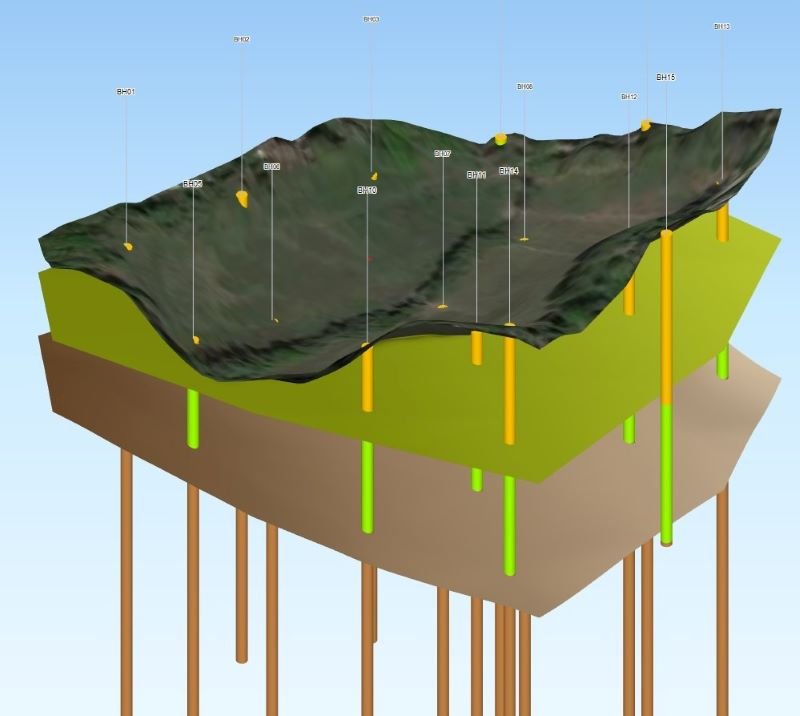
3D models are perhaps the glamourous side of our industry. Pretty looking models spinning around make for good copy, especially on social media, and they are great for engaging clients and colleagues. I don’t have a problem with this. However, I do have one little gripe I would like to share…
Have you ever tried using one of these models to get some useful information? For example, what does my model (in the figure above) tell you about what is going on in the middle of the site? Difficult to see, isn’t it, whichever way you spin it around (you can’t spin this one around by the way – sorry – my web design skills are not quite up to that yet!) If my model was a proper volumetric model with solid sides to the geological units, which most are these days, then you would see even less.
Most of the time, to get anything useful out of a 3D model we need to slice a 2D section through it. The software we use generally provides the tools to do this of course, although some are better than others in their ease of use and what they provide. Sometimes, all we end up with is a nice looking section but without a simple means of extracting the dimensions or co-ordinates of a particular feature, and we end up measuring off the screen! Come on, admit it – we have all done it!
So, my first challenge is: 3D ground models should be for use, not just for show! This is mainly aimed at software developers, for the ultimate benefit of the engineers and geologists. I would like to see visualisation tools that are fast, intuitive to use and provide the information that we need for design, without us having to resort to scripts or workarounds.
First fuse lit!
Celebrating the borehole log – a design classic?
I do not know when the first diagrammatic borehole log appeared, but it would not surprise me if it was more than 100 years ago. Borehole logs have changed surprisingly little over time. Why? Because it is a design classic that really works! We get a lot of useful and necessary information presented to us in a concise and intuitive visual form.

I am pleased to see that the humble borehole log is still with us. However, I am a bit surprised and disappointed that, despite all of our technology and knowhow, we have not significantly improved upon it for the digital age. What I mean it that we generally still only see borehole logs created in traditional paper form, albeit digital paper these days, i.e. as a fixed content PDF. It is still the norm to have the log stopping at the bottom of one page and starting again on the next, and yet we are reading these on devices that can scroll around an infinite page. In addition, surely we can leverage technology to allow us to easily interrogate the data behind the borehole log, which for far too long has remained hidden away within the factual report.
Therefore, my second challenge is: let’s bring the borehole log into the 21st century. It is already in pretty good shape, so treat it with care. Think improve, not replace. I have dropped a couple of hints on what we could do with it, but I’m sure you could come up with other ideas too.
Geotechnical reports – not a design classic!
Geotechnical engineers like to write reports, so much so that we have enshrined our desire for writing reports into Eurocode 7 and some major client specifications.
Like the borehole log, geotechnical reports, be they desk studies, factual reports, interpretative reports or design reports, have changed little over the last few decades. Maybe they look a bit prettier these days, and they now get exchanged as PDF files, although this is not necessarily an improvement, especially if they are not bookmarked! Geotechnical reports are still generally wordy, not especially visual, and mostly seem to be written for the benefit of the author, not anyone unfortunate enough to be on the receiving end. They are certainly not design classics, in my opinion. Comment below if you disagree.
So what has this got to do with digital? My concern here is that we have some good people out there coming up with great digital workflows … for producing the same old style of geotechnical report. That is a shame, and a missed opportunity. The world has moved on. No-one wants to read these reports front to back anymore (if they ever did). We should be rethinking what we produce, as well as the means of producing it.
My final challenge (for now) is directed at all geotechnical engineers, not just the digital specialists. Let’s rethink geotechnical reports for the digital age. This should start with a critical review of requirements, i.e. what do we really need from them? Only then should we look at how the information is presented, and how it is pulled together. There may be several valid ways of approaching the latter.
How can we reap the benefits from digital?
The digital revolution provides a once in a generation opportunity for us to rethink what we do and how we do it. I would like to see us paying a little bit more attention to the what (and why) before we go too far down the line with how.
There are some technologies and potential new ways of working out there that that will require us take a completely fresh look at what we do, and we need digital specialists to help us discover and leverage these. However, we should not shy away from seeking some easy wins by upgrading some of our current tools and processes. I have provided some examples. We need ground specialists and the digital specialists working together, identifying the right solutions to the right problems.
The ultimate success of our industry’s digital transformation will be judged on outcomes for projects, and for society as a whole. Pretty spinning 3D models may be encountered during the journey, but they are not the destination!
Related article
For more of my thoughts on digital transformation in the geotechnical domain, check out this article that I co-authored for the AGS magazine: https://www.ags.org.uk/2021/07/digital-transformation-in-ground-engineering-hopes-and-fears/
Interesting first blog Neil, good luck with this initiative and the new business. I could comment on all three challenges you have posed but I will kick off with a reflection on the first. Most 3d models from other design disciplines allow the viewer to walk through the model. Maybe that is a way of investigating the buried strata in the middle of the model?? I am sure digital designers could come up with some useful and intuitive devices to illustrate the budding model miner!
Hello Mr. Neil,
Warm Greetings!
First of all many congratulations on your new venture – ‘Digital Geotechnical’.
I agree with your content on all the three topics, because these are very much the same over the year in a slightly different way.
In my very personal professional experience, I have observed, the data being showcased but not used.
Before even jumping into digital transformation, the industry needs to understand that data is for usage not for sale (dig not only to comply with the codes or standards or authorities) .
Once we all understand the real importance of the data and its benefits for the greater good, then it will automatically leverage the transformation we want for the 21st century.
Please keep posting!
Thanks & regards,
Prasanna G
Thanks Neil – great initiative and topics! So much agree with your first challenge relating to 3D usability – very difficult to show as much info as on a long-section. 3D models (with sufficient data spread relative to the ground conditions) are great to generate more realistic 2D long sections (for use in 2D design etc) but usually these 2D outputs are pretty poor. For the second challenge on the logs, interrogating the data would be great, keeping in mind logs will always contain very little information compared to an AGS database that can quickly be imported then interrogated with a management software